I. INTRODUCTION
Lundin has been accused of suspected complicity in the displacement of people in order that it might carry on its business of oil exploration. This chapter examines how Sudan’s laws, its conflicts, and environmental conditions both natural and man-made, resulting in floods, drought, and food shortages, together with the provision of aid, all had an impact on the movement of peoples. This chapter provides a contextual background to the situation in which the Company was operating in Sudan.
All states compete with their citizens over the use of land. Motorways, railways, energy, and community development projects for which the state compulsorily purchases land from those with legal rights, are a feature of life in all nations. Sudan’s development of its natural resources in the form of oil was legitimate, lawful and in the interest of the State and the states, as established in the 1997 KPA. The Petroleum Wealth Act of 1998 placed the ownership and regulation of petroleum firmly in the hands of the national government. Moreover, the United Nations General Assembly consistently supported developing countries’ rights to regulate and control the exploitation of their natural resources.lix
The extent of Lundin’s involvement in the State’s development of its natural resources was extremely limited. The Company was a minor contributor to the overall drilling activity in the area known as the Muglad-Sudd Rift Basin (Muglad Basin) in Sudan. The basin is situated within southern Sudan and covers an area approximately 750 km long and 250 km wide. During the period 1997-2003, 235 exploration, appraisal and development wells were drilled in southern Sudan. The Company drilled just four in Block 5A, accounting for only 1.85% of the total number of wells drilled in the Muglad Basin.lx Two of the wells were exploration wells (Thar Jath-1 and Jarayan-1) and two were appraisal wells (Thar Jath-2 and 3).lxi Lundin did not produce any oil or gas at any stage from its two discoveries in Block 5A.
The majority of discoveries (39) were made by the Greater Nile Petroleum Operating Company (GNPOC) in Blocks 1, 2 and 4.lxii GNPOC was the dominant operator in this period and drilled 140 exploration and appraisal wells (accounting for 64.81% of the total wells drilled in the Muglad Basin). Whereas activity within Block 5A was at an early stage with minimal exploration activity and low expenditure compared with the other blocks in the Muglad Basin.lxiii See the map showing wells from 1997-2003 and the limited extent of Lundin’s activities in Sudan in Annex 1.
II. SUDAN: GEOGRAPHY
The landscape of southern Sudan is vast and sparsely populated. Sudan before its division was the largest country in Africa: covering over 2,500,000 square kilometres. The country formed eight per cent of the African land mass and was counted among the ten largest countries in the world. There is arid desert to the north and semi-arid lands to the south. The two main constituents of the Nile flow into southern Sudan, joining at Khartoum then flowing as one to Egypt. This arterial confluence has had agricultural, cultural, and historical significance for millennia. It is a conduit for trade, the movement of people between north and south and for commerce as well as conflict, conquest, natural resource exploitation and slavery. Arab groups have entered Sudan at various times from the east and traders have also travelled eastwards through the Sudanese savannah along trade routes to Mecca. These movements over history have led to frequent periods of conflict.lxiv Demographic data is difficult to collate as current and historical statistical information is unreliable and uncertain. Mortality rates across the spectrum are among the highest in the world.lxv Over 70% of the population lives in rural areas. The population density is calculated overall at twenty persons per square kilometre.lxvi
lix
“See UN GA Resolution 1803 (XVII) on the Permanent Sovereignty over Natural Resources; UNGA Resolution 2158 (XXI); UNGA Resolution 3167, Appendix 199; UNGA “Declaration on the Establishment of a New International Economic Order”, appendix 200; UNGA 3281 (XXIX) Charter of Economic Rights and Duties of States, Appendix 202.”

A great tract of the southern part of the country (the Sudd) is flooded for months during the rainy seasonlxviii and there is little in the way of roads or other infrastructure.lxix The swamps are inhospitable, save for wildlife, and the population density of the Sudd is low. It is difficult to calculate precisely the extent of the swamps since it will vary according to whether it is the dry or the wet season. The Sudd, however, is considered to be one of the greatest wetlands of the world. People gather along major rivers, lakes and flood plains. The Dinka and the Nuer people co-exist in the Sudd and depend upon the annual floods and rains to regenerate the floodplain grasses on which their cattle feed. There is, for that reason, a perpetual cycle of movement of people and livestock from higher land, in the wet season, to lower land when the floods subside, and cattle can graze. In relation to Block 5A, as shown in the map below, one-third of the area is swampland, which also covered Thar Jath, the site of Lundin’s drilling. During the wet season, a period of at least six months of the year, the flooded area extended to cover the area to the west of Thar Jath. In this environment Lundin operated for only 23% of the period 1997-2003. See the maps below for further information.
Map Showing Sudan and Demarcation of South Sudan lxvii

The following maps show (A): South Sudan with neighbouring states (source: OCHA 2020); (B) Unity State (also formerly known as Western Upper Nile) where Block 5A is located (OCHA 2012); (C) Block 5A and (D) Block 5A overlaid on Unity State for scale (dated 2005).
Utility and Block 5A Swamp Calculations
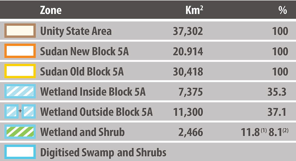
Calculations of Area made with ESRI Arch-View Mapping Software
1) New Block 5A 2) Old Block 5A

Map of South Sudan (A) lxx
Map of Unity State (B) lxxi

Block 5A (C) lxxii

Block 5A Overlaid (D) lxxiii

III. LAND OWNERSHIP, ALLOCATION AND MANAGEMENT IN SUDAN
More than 95% of Sudanese land legally belongs to the State.lxxiv The conditions of life in Sudan are such that land use by rural communities and pastoralists is upon land over which they have no legal rights. Instead, these communities have what is described as legitimacy of use.lxxv The Government’s view of land management is that: “When land belongs to the Government there is generally no problem regarding access or tenure security. If there is a problem, the Government will solve it” (Legality of tenure).
However, land management in the south was viewed differently: “All rural land belongs to the people and is held under customs. To date there is no major problem with this system” (Legitimacy of tenure).lxxvi Therefore, customary land use whilst considered legitimate, was without legal rights.
The Sudanese Unregistered Land Act, 1970lxxvii was passed to permit the legal acquisition by the State of large tracts of land for agricultural schemes. The purpose at the time was to enable Sudan to develop its food production more effectively for its people. All unregistered land including that used by rural dwellers and pastoralists, was transferred to the government, permitting it to assign it for development to any public or national enterprise, as well as to farmers on a leasehold basis. The Act applied throughout the country, even in the South where there was no system of land registration in force.lxxviii Article 8 states: “If any person is in occupation of any land which is registered or deemed to be registered in the name of the Government, the Government may order his eviction from such land and may use reasonable force if necessary”.lxxix This provision meant that prior users lost the right to use, or be compensated for, land rights incorporated into any planned agricultural programme. Traditional farmers had to be relocated, often to less productive areas. There they may have found little infrastructure and few water resources, causing them in many cases to move again in search of resources. Over decades, the process of continued expanding agricultural production meant that extensive areas were placed under mechanised cultivation in the bid to increase food production.
Whereas entrepreneurs, urban dwellers and elite groups were able to use the legal system to obtain new rights over land through leaseholds, such procedures were not familiar to the great majority of the people, nor well adapted to their needs. The customary system was used by the majority of land users to secure their existing rights. Although these may not have been legally recognised, the rural population considered them legitimate. This gap between the legality of the state’s system and the legitimacy of the customary systems was the main reason why tenure over land was not secure.lxxx The State was able to impose mechanised farming over large areas of northern Sudan. Thus, thousands of people were expropriated without compensation and lost access to the land where they had lived and made their living. Pastoralist tribes, who were often the poorest and most vulnerable to conflict, lost their tribal homelands as a result of business-driven agricultural activities. The result was that such groups of summarily displaced people were permanently on the move, in turn provoking conflict as they passed through new lands.lxxxi
IV. OIL AND MINERAL RIGHTS
A general provision of the Civil Transactions Actlxxxii provides that the owner of land owns the adjacent soil below it to the extent of its useful limit. With respect to petroleum products, including oil and natural gas, legislation, including the Petroleum Wealth Act 1998 provides that all such products are deemed to be the property of the state, for which no one may search or produce without a licence or lease granted by the government.
The 1998 constitution established that “natural resources under or on the surface of the earth and in territorial waters is public property regulated by law and the State shall provide plans and appropriate conditions for the development of the financial and human resources necessary for utilising such wealth”, provisions similar in a majority of countries in the world.lxxxiii Other legislation recognises that “things discovered” on privately held-land may belong to the land-owner but since 95 per cent of the land belongs to the state a combination of the provisions in the Civil Transactions Act and the Constitution will ultimately prevail against the claims of others.
V. LIVELIHOODS AND CONFLICT
Overall, Sudan and southern Sudan should have had great potential both in terms of resources and cultivable land. It should have been capable of achieving food self-sufficiency,lxxxiv exporting food to diverse markets and benefitting from the huge quantity of natural resources available. However, for decades it has lacked peace, political stability, infrastructure, capital, and expertise to reach its investment potential.lxxxv
In southern Sudan, the prevailing way of life is traditional agriculture and the raising of livestock. This leads to acute competition and conflict over natural resources among the various communities. Farmers and nomadic herdsmen in undeveloped rural areas have historically clashed for long-standing reasons, some unconnected with resources, such as tribal divisions and revenge for real and perceived provocations, such as cattle raiding and fighting over fishing rights.lxxxvi By way of example, between 1993 and 1994, conflicts between the Jikany and Lou sections of the Nuer people resulted in 1,500 dead and 75,000 cattle stolen.lxxxvii These clashes were exacerbated by increases in human and animal populations, other outside influences and the devastating effect of the proliferating presence of weaponry.lxxxviii Armed conflict often involved not only aggression directed towards the opposing group but the destruction of property and environment. However, the reality is alliances were fluid and groups rarely defined along clear lines. They were more opportunistic and based around loose groupings of individuals serving their
own interests over a greater communal cause. The split in the SPLA in 1991 empowered and increased levels of violence and inhibited access to grazing and fishing areas. This drove and reinforced divisions, competition and mistrust.lxxxix Block 5A was no exception to this as the local grievances persisted and continued the historic patterns of conflict.
VI. INSTABILITY
Despite the KPA, the conflicts in southern Sudan bequeathed a widespread shortage of resources, little or poor access to services, and the disruptive presence of armed combatants whose energies swiftly turned from the wider conflict to destructive action within or outside their communities.xc Refugees from the conflicts, fled into traditionally held territories, increasing competition for resources, fomenting tensions and spawning further violence.xci There was no effective system of justice that would serve as a deterrent to these activities and the customary laws that had previously held these populations together unravelled.xcii
The prolonged conflicts within and between communities resulted in the destruction of the physical, social, economic, and political infrastructure. Poverty, food insecurity, broken family structures and relationships, greater numbers of IDPs and, inevitably, death and injury followed. In 1983, there were between 6–7.5 million (statistically uncertain) southern Sudanese, by 2000, 3–4 million remained.xciii The inter-factional conflicts in the 1990s are believed by some observers to be responsible for 90% of internally displaced people in Sudan.xciv The impact of these perpetual conflicts was felt in the absence of health workers, teachers, transport and even basic commerce.xcv
None of these services could be financed except by international aid donors, humanitarian organisations and the churches. Following on from the poor harvest in 1997, 150,000 people moved to Bahr el Ghazal.xcvi The whole region was struck by severe food shortages, famine, with significant loss of human life. Rains arrived late in the affected areas and were followed by severe floods, which destroyed crops on 100,000 hectares of land.xcvii During the Bahr el Ghazal famine, food aid was dropped in an attempt to prevent all the civilians from starving. It was later found that rebel military commanders, clan leaders and local tribal chiefs had appropriated most of the aid.
VII. DROUGHT, FLOODS, FAMINE AND AID
In his 2001 UN report for the Food and Agriculture Organization, (“Legality and Legitimacy: A Study of The Access to Land, Pasture and Water in Sudan”), Paul de Wit found that “access to land and other resources” was “the root cause of a wide number of present and latent conflicts”.xcviii From the 1980s and through the 1990s, droughts were an increasingly frequent problem, accompanied by the desertification of Sudan. This led to the movement of people seeking to improve their socio-economic conditions and basic chances of survival. Increased conflicts for water, grazing land, and fishing rights, particularly between the major southern ethnic groups, the Dinka and Nuer, were also a reason for and consequence of displacement.xcix
Tribal and inter-factional conflict were the main causes of displacement.c The “People-to-People” peace process, which began in 1998, was established to stop these destructive conflicts in the south. The disruption caused by the fighting affected food supply, leading to hunger for hundreds of thousands of people. A report from 1998 refers to how heavy flooding compounded these food shortages experienced by a population already affected by conflict in Western Upper Nile (WUN) and Unity State.ci The availability of international humanitarian aid affected displacement in that it became part of the reason why people moved to areas and chose to stay.cii Desertification occurs as a result of severe environmental degradation caused by agricultural production and livestock rearing. Droughts have been endemic in Sudan, causing conflicts over dwindling available resources, such as water and grazing land for decades. Whilst the reduction in cultivable land, has led to soil erosion, loss of soil fertility and infestation. This, in turn, led to the adoption of pastoralism by a large part of the population as a means to carve out a sustainable living, necessitating movement by the people in search of better conditions. The practice of burning old grass to enhance the fertility of the land was also prevalent in southern Sudan, as noted by Lundin when refuting allegations by Christian Aid of a scorched earth policy:
“Burning of land in South Sudan, as in many other African countries, serves for agricultural purposes where high grass is burned in dry seasons in order to turn into fertilizer in rainy seasons. People in the area are nomadic and move according to seasons and agricultural requirements which can differ from year to year. “ciii
Chart Showing Droughts in Sudan civ

The conflicts in the south began largely in towns, forcing the inhabitants into rural areas, and were characterised by confrontations between the two populations of Dinka and Nuer, often ignited by perceived inequality of resources manifested by the theft of cattle, women and children and over grazing rights.cvi Aid became a factor in the perception of inequality as people fought to control it. Aid also became a major factor in supporting and sustaining the conflicts in south Sudan over time. Factional and (intra) tribal fighting are at the root of displacement in the 1990s, as are the self-serving interests of many factional group leaders.cvii Aid became a main driver of the south Sudanese economy either through provision of food and resources, as well as providing jobs for those with requisite skills. Cattle raids and grazing clashes amongst the Nuer and Dinka were responsible for more deaths and suffering than the conflicts between the Government of Sudan and southern rebels.cviii These clashes disrupted what cultivation was possible because the opportunities to farm were diminished and fields, which were not in the vicinity of dwelling places, were abandoned and left unused. This had the resultant effect of increasing food insecurity in later years.
VIII. CONCLUSION
There is no single reason for the movement of people in Sudan. Movement was caused by a combination of natural and political reasons and to contend that oil was somehow responsible is to disregard all the other social and environmental conditions and influences that existed and combined to cause instability.
Block 5A was a vast, sparsely populated territory. Lundin operated intermittently in one small, remote part of it and withdrew, suspending its operations for long periods of time. Between 1997 and 2003, the Company was a minor contributor to the overall drilling activity in the ‘Muglad Basin’ and operated on average less than three-months per year (23%) in Block 5A due to a combination of seasonal constraints (wet versus dry season) and suspensions due to instability in the area.
Lundin never progressed beyond exploratory and appraisal drilling and seismic soundings. Not one barrel of oil was ever brought commercially to the surface. The footprint left by these activities was miniscule in comparison to the size of the Block.
lx
During the period 1997 to 2003, 235 exploration and appraisal wells were drilled in Sudan. Of these only 4 were in Block 5A, operated by Lundin, paras 4-5, p.4 of the Gaffney Cline report. Note that in relation to Thar Jath-1, Lundin only established successful testing of this well in March 2001, and therefore Thar Jath-1 was only considered a discovery at that point: para 33, Gaffney. By the end of 2003, Lundin’s Thar Jath discovery was still not fully appraised, and required further appraisal drilling to confirm a potentially commercial discovery, warranting possible development: para 36 Gaffney Repo
lxi
Gaffney Cline Report, p.12. Note that in relation to Mala-1 marked on the map, after Lundin had sold its
interest in Block 5A and was no longer present in Sudan, a consortium of Petronas, ONGC and Sudapet
developed the Thar Jath and Mala fields. Mala-1 was spudded by WNPC in June 2003 with completion in
July 2003 – Gaffney Cline report, p. 4-5.
lxii
Id., para.8. GNPOC is the Greater Nile Petroleum Operating Company, a joint-venture consortium
comprising CNPC (40&), Petronas (30%), Talisman (25%) and Sudapet (5%).
lxiii
Id., para.13.
lxiv
Jenner, Hadley, “When Truth is Denied, Peace Will Not Come”, The People-to-People Peace Process of
the New Sudan Council of Churches, October 2000, p.3.
lxv
“The most recent census, in 2008, recorded a total population of 39 million, but it probably understates
the population both of Darfur (recorded as 7.5 million) and of Southern Sudan (8.2 million), either as a result of flawed data collection or manipulation of the results. The uncertainty over how many people actually live in Sudan is the most striking example of a recurrent problem in Sudan, statistics are generally unreliable or contested or both”. Willis, Egemi and Winter in the ‘Sudan Handbook’ (2011) p.16.
lxvi
Worldometer for 2000 the population density of Sudan was calculated as 15 psqk (Column 8). The
population of Unity state was assessed to be 660,000 compared to Khartoum’s 6 million.
lxix
Hopkins, Donald R. and Withers Jr, P Craig, ‘Sudan’s War and Eradication of Dracunculiasis, The Lancet
Supplement, Vol.360, December 2002. See also, https://whc.unesco.org/en/tentativelists/6276/
lxx
Office for the Coordination of Humanitarian Affairs (OCHA), January 2020.
lxxi
Office for the Coordination of Humanitarian Affairs (OCHA), map dated: 26/03/12.
lxxii
Internal reference map
lxxiii
University of Berne 2005.
lxxiv
De Wit, Paul, ‘Legality and Legitimacy: A study of the access to land, pasture and water – Sudan, Special Relief Operations, Food and Agricultural Organization of the UN, Rome 2001’, p.4 (“A study financed by the European Community prepared for the IGAD Partner Forum Working Group on Planning for Peace in Sudan
by the FAO UN”).
lxxv
De Wit, Paul, “Legal Legitimacy” FAO, p.4.
lxxvi
Id., p.4.
lxxvii
Id., p.7.
lxxviii
Gordon, Carey N., ‘Recent Developments in the Land Law of the Sudan: A Legislative Analysis’, Journal of African Law, Vol.30, No.2 (Autumn, 1986) p.148: “On April 1970, legislation was promulgated stating that “all land of any kind whatsoever, whether waste, forest, occupied or unoccupied, which is not registered before the commencement of this Act, shall, on such commencement, be the property of the Government and shall be deemed to have been registered as such.” The Civil Transactions Act, 1984, now provides that and registered on or after 6 April 1970, as freehold in the name of an owner shall be deemed merely the ownership of the ‘usufruct’ thereof. ‘Usufruct’ is defined as the right to use property that belongs to another person. In other words, the 1984 legislation maintains the rule, originally enunciated in 1970, that as to land for which full ownership was not registered in the name of a private person prior to 6 April 1970, the state is deemed to be the owner thereof, although the right to use such land may belong to a private party.”
lxxix
Unregistered Land Act, 1970: The Unregistered Land Act (1970) served to nationalize all unregistered land
in the country.
lxxx
De Wit, Paul 2001, p.4.
lxxxi
Id., p.28.
lxxxii
“The Civil Transactions Act, 1984 (C.T.A.) was promulgated on 14 February 1984 and took effect on that date. It comprises some 95 chapters with 819 separate sections, more than one-third deal with matters relating to land. The original text of the law was promulgated in Arabic.” Gordon (1986), pp.143-144.
lxxxiii
Article 9 Sudan Constitution 1998.
lxxxiv
Economic Trade Between Africa and the European Union (with special reference to Sudan), inaugural
dissertation, September 2006/07, Universitat Freiburg im Breisgau
https://freidok.uni-freiburg.de/fedora/objects/freidok:3154/datastreams/FILE1/content
lxxxv
Id.
lxxxvi
Jal, Gatluak Ruon, ‘The Roots Cause of Cross Border Conflict in Gamballa Regional State Between Jikany-Nuer and Lou-Nuer’, Public Policy & Administration Research, Vol.4, No.8, 2014: “The respondents who participated in the first day of fighting between Jikany-Nuer and Lou-Nuer revealed the first fighting erupted on March 27, 1993 in place called Dualdap in South Sudan. The results supported the fighting that started in South Sudan between Jikany-Nuer and Lou-Nuer in 1993 expanded to Ethiopian Jikany Nuer in Akobo district within the same year. The information obtained from the field work revealed, because Lou-
Nuer area does not have river and water pool during dry season, every year, they move with their cattle to river side which is occupied by Jikany-Nuer. In 1993 Lou-Nuer under the community leader called Machot
Dak moved to river side where they met Jikany-Nuer, the place called Dualdap. Because they left their food
items they want to fish to get something to eat as they felt hungry. The respondents explained the Jikany- Nuer did not allow Lou-Nuer people to fish because they have to inform other people. The results supported it is the culture of Nuer when there is fishing pool which is not yet touched they will inform all people around for specific day they will first start fishing in that pool. The Lou-Nuer wait for two days but Jikany-Nuer did not come to inform them when it will be possible to fish. After these days some Lou-Nuer went to river on their will and put their nine fishing nets in the river. When the Jikany-Nuer knew that the Lou-Nuer had put their fishing nets in the river they came and pulled the nets out. As the Lou-Nuer came to take their nets there the two groups disagreed and the fighting erupted. The respondents explained that was the first incident of fighting between Jikany-Nuer and Lou-Nuer in the history. From that fighting up to five people were shot dead from both sides.”
lxxxviii
Hutchinson, Sharon, Nuer Dilemmas: Coping with Money, War and the State, 1996, p.27.
lxxxix
Schomerus, Marieke & Allen, Tim, ‘Southern Sudan At Odds with Itself: Dynamics of Conflict and
Predicaments of Peace’, DESTIN London School of Economics, (2010).
xc
Report of Visit to Nyal and Gangliel in Preparation for the Coming Nuer-Dinka Conference (West Bank),
by Rev. Mathew M.Deang, Justice and Peace Coordinator, Upper Nile, October 1998,
xci
Bradbury et al, ‘Local Peace Processes in Sudan: A Baseline Study”, (2006); and Schomerus & Allen
(2010).
xcii
See for example, ‘A Study of Customary Law in Contemporary Southern Sudan’, by Justice Alue Akechak Jok et al for World Vision International and the South Sudan Secretariat of Legal and Constitutional Affairs, March 2004.
xciii
Jenner, Hadley “When Truth is Denied, Peace will not Come” (2000) p.5.
xciv
Id., at p.5.
xcv
Id.
xcvi
“In May 1998, FAO issued a Special Alert on the grave food supply difficulties in southern Sudan,
particularly in Bahr el Ghazal, as a result of a succession of drought-reduced food production coupled with an intensification of the long-running civil strife. Later in the year heavy rains and flooding displaced a large number of households and damaged crops in the central and eastern parts of the country.” Source:
xcvii
Evaluation of Danish Humanitarian Assistance to Sudan 1992-1998, Final Report, October 1999, Overseas Development Institute p.83: “This chronic conflict, during which people received only minimal
humanitarian input, has progressively depleted resources and people’s ability to cope with natural and man-made deprivation, displacing many families and destroying cattle and stores. By the end of 1997 the food security and health situation of the population was deteriorating seriously - for example, TB was a major and increasing threat to the population. An epidemic of Kalazar was raging in Western Upper Nile and Guinea Worm was highly endemic. More usual problems such as diarrhoeal disease and respiratory tract infections were also common as a result of poor water and living conditions."
xcviii
De Wit. Paul (2001), p.33.
xcix
From, Willis, Egemi and Winter in ‘The Sudan Handbook (2011), p.20: “In the last few decades, as a result of state intervention, civil war, famine and in some areas of the north, increasingly unreliable rainfall – and the consequent disruption of traditional systems of food production – Sudan has seen dramatically accelerated population displacement. Millions of people have been forced to move. Rural-urban migration has resulted in dramatic changes in the population landscape ... Sudan’s porous international borders with Chad, Eritrea and Ethiopia mean that it has also played host to many hundreds of thousands of refugees from wars in these countries.”
c
In the opening ceremony to the Wunlit Peace Conference Governor Nhial Deng Nhial said: “…There are still a minority among us whose interests are being served by the perpetuation of the suffering of our people. There are still people among us, and in our two communities, and some of these are well placed. They want to exploit the tragic events of 1991 and call our peoples to take revenge. But what they want is not really revenge but rather to perpetuate the raids for property and cattle to increase their wealth”. Dinka and Nuer West Bank Peace and Reconciliation Conference, transcripts from Wunlit.
ci
A report from 1998 from WUN says: “75% of the people in Payinjar district south of Leer area of Nyal and
Gangliel are due to flooding, the villages concerned are Gakal, Youb, Palual, Tharbar, Nyadoung, Pathiel and Luali.”… “Also there were reports that the area south of Leer was affected most by the flooding and that in the villages the children are malnourished.” http://sudaninfonet.tripod.com/Nuer-Dinka/MMD-Report.html
cii
See François Grünewald (FAO Consultant), ‘Uprooted People in Sudan: From Drought and War to Peace and Development’, Consultancy on the Rehabilitation and Reintegration of IDPs & Returnees for the IGADPartner Forum Working Group ‘Planning for Peace’, June 2001.
ciii
Lundin Oil in Sudan May 2001
cv
Id., “Periods of drought have occurred throughout Sudan’s history and in most cases have been followed by famines and outbreaks of disease (Babiker, 1985; 1990). Table 11 indicates diversity in the spatial
incidence of drought and famine, with frequent occurrences concentrated in the western and eastern
regions.”, Drought Characteristics and Management in North Africa and the Near East, FAO UN Water
Reports 45, Rome 2018. http://www.fao.org/3/ca0034en/CA0034EN.pdf p.59
May 1998 FAO report: http://www.fao.org/3/w8701e/w8701e00.htm
cvi
See for example Stringham and Forney, ‘It Takes a Village to Raise an Army’, (2017)
cvii
Scroggins, Deborah, Emma’s War, (2003), p.258.
cviii
Grunewald “Uprooted People in Sudan” (2001).
Chapter 2:
Land Ownership, Famine, Drought, Floods and Displacement